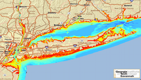
New Mapping Tool Shows Tidal Power Potential
Posted by Big Gav in ocean energy, tidal power
IEEE Spectrum has an article on efforts to map tidal power potential in the US - New Mapping Tool Shows Tidal Power Potential.
A group at Georgia Tech University has created a database-driven mapping tool aimed at illustrating the tidal power potential around the coastlines of the entire United States. The map was validated by the Department of Energy, and is now available to all.
There aren't yet any major tidal power installations in the US, but according to the DOE, the map indicates strong potential in both the Northeast and Northwest. Some related projects do exist, like turbines under the East River in New York. Atlantis Resources Corporation, which makes a double-turbine type of tidal power device, has several projects under development around the world, including in India.
And as with any type of energy, assessing tidal power's practical generation potential is the first step. Though some reports have suggested a global capacity of 90 gigawatts, or a US potential equaling 15 percent of total electricity requirements, assessments on a more local, project-specific level will now be easy with the Georgia Tech map.


